 Walking Tour-33 North Main Street-Walking Tour
(West Side of Street)
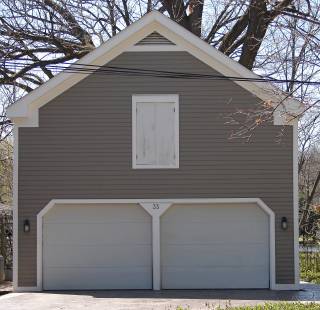
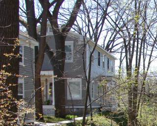
The first photograph is the garage for the house, second photograph, which is behind to the west. The buildings were both built in the early 1970s.
The house and garage seen on this lot now were built in the 1970s. A glimpse of one of the buildings which once stood on the portion of the lot may be seen on the right in the photo, page 59, Heritage. A 1908 Map of the Village has only one building footprint on Lot 3 at that time.
Official Property Description:
- The north part of Lot 3 Block 18 of Nelson W. Clark's Plat of the Village in the Southeast 1/4 of Section 20 in Independence Township.
- Lot - 017 of the Supervisor's Replat of the Northwestern Addition & Part of the Original Plat.
Significant Property History:
[A Synopsis Of Property Transfers Derived From Abstracts
(when available) And Periodic Changes In Ownership Or
Assessed Value Derived From Township Tax Records]
- Note: All the properties currently located in the Historic District were originally part of a tract registered by Butler Holcomb with the federal government on October 22, 1831. Thus, abstracts for these properties, when they exist, show the original transfer to be from the United States to Butler Holcomb and may also include references to then President Andrew Jackson.
- See 21 North Main for tax record information.
Originally this property did not extend all the way to the east edge of the Mill Pond shore. A public way ran along the shore running north from W. Washington to the stream/spillway from the Mill Pond to Park Lake. The public way was vacated in favor of the riparian owners.
Site Conceived By
And Grant Funding Obtained By
Mollie Lynch, Library Director 1991-2005
Researched And Written By Susan K. Basinger
Web Pages Designed And Built By Bill And Susan
Basinger
Contents ©2000 Independence Township Library
All Rights Reserved