 Walking Tour-21 North Main Street-Walking Tour
(West Side of Street)
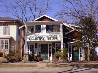
This building was Wilson R., "Wiltsie", Vliet's cabinet shop from circa 1880 until at least 1914. See photo, page 55 , Heritage. Vliet built boats as well as cabinets and furniture. According to a 7/24/1902 Pontiac Post newpaper item, "The largest row boat ever constructed in Clarkston, is being built by W. R. Vliet for Mr. Williams of Windiate Park." (Waterford). A January item in the Post said, "Wilson R. Vliet is getting logs for his sawmill which he will have in the same place as last year." "W. R. Vliet has moved his sawmill from Robert Reid's to George Miller's farm" by April according to an item of the same year. These farms were outside the Village. Petty Art Studios, later Petty Photography, occupied the second floor at the turn of the century. A circa 1905 photo taken from the east edge of the Mill Pond shows a number of small buildings on this lot at that time.
By 1950 Jean Weighall Looker Megee, Mrs. Lloyd Megee, owned the building where she operated "Ye Olde Tyme Shoppe", an antiques & gifts store. A Clarkston News advertisement for Ye Olde Tyme Shoppe said a circulating library was located in the shop; that it was an agency for Klad-Ezee Garments for Children; and that it was an Agency for Ridley Cleaners. The ad was in a 1932 paper but Ms. Looker/Megee was not cited in the tax records for this site. Apparently she rented the building before actually owning it..
Official Property Description:
- Part of Lot 3 Block 18 on Nelson W. Clark's Original Plat of the Village in the Southwest 1/4 of Section 20 in Independence Township.
- Lot 17 of the Supervisor's Replat of the Northwestern Addition & Part of the Original Plat.
Significant Property History:
[A Synopsis Of Property Transfers Derived From Abstracts
(when available) And Periodic Changes In Ownership Or
Assessed Value Derived From Township Tax Records]
- Note: All the properties currently located in the Historic District were originally part of a tract registered by Butler Holcomb with the federal government on October 22, 1831. Thus, abstracts for these properties, when they exist, show the original transfer to be from the United States to Butler Holcomb and may also include references to then President Andrew Jackson.
- 1832 Butler Holcomb, the Northeast 1/4, the Southeast 1/4, the east 1/2 of the Northwest 1/4 and the east 1/2 of the Southwest 1/4 of Section 20.
- 1835 Butler Holcomb to Jeremiah Clark, the south part of the east 1/2 of the Southwest 1/4 of Section 20.
- 1839 Jeremiah Clark to Nelson W. Clark, one equal undivided 1/2 of the south part of the east 1/2 of the Southwest 1/4 of Section 20.
- 1842 Nelson W.Clark's Plat of the Village.
Originally on Nelson W. Clark's plat, this property did not extend all the way of the east edge of the Mill Pond shore. A public way ran along the Mill Pond shore extending north from W.Washington to the stream/spillway from the Mill Pond to Park Lake. The public way was vacated in favor of riparian owners.
- 1843 N. W. Clark & Phidelia Clark to Polly Clark, Lots 3, 4, 5 & 6 Block 18.
- 1844 Jeremiah Clark, Lot 3 Block 18, assessed value $5.
Jeremiah Clark, Lot 4 Block 18, assessed value $5.
Jeremiah Clark, Lots 5 & 6 Block 18, assessed value $200.
- 1846 Jeremiah Clark, Lots 3, 4, 5 & 6 Block 18, assessed value $200.
- 1847 Jeremiah Clark, Lots 3, 4, 5 & 6 Block 18, assessed value $200.
- 1848 Polly Clark, Lots 3, 4, 5 & 6 Block 18, assessed value $260.
- 1849 Polly A. Clark to Myron G. Cobb, Lots 3, 4, 5 & 6.
- 1857 David Hoyt.
- 1867 William V. Vliet, Lots 3 & 4, assessed value $350.
- 1872 Herbert & Lewis, the north 1/2 of Lot 3 & part of L ? Block 18 in the northeast corner, 2 rods front, 5 rods up on the west from Main, assessed value $75.
J. M. Haight, the west 1/2 of Lot 3, 5 rods back on the northeast corner thereof, assessed value $25.
Map of the Village has two building footprints on the Lot labeled G. Vliet.
- 1875 J. M. Haight.
- 1880 George W. Vliet, the north 1/2 of Lot 3, assessed value $100.
Wilson Vliet, the south 1/2 of Lot 3, assessed value $200.
Matilda Demerest, the west 1/2 of Lot 3, assessed value $50.
- 1883 Wilson Vliet, the south 1/2 of Lot 3, assessed value $150.
Mrs. Mary Howe, Lot 4 & the north 1/2 of Lot 3, assessed value $500.
- 1885 Wilson R. Vliet, the south 1/2 of Lot 3, assessed value $50.
J. P. Carran, Lot 4 & the north 1/2 of Lot 3, assessed value $400. (& the north 1/2 of Lot 2.)
- 1888 J. P. Carran, Lot 4 & the west 1/2 of Lot 3, assessed value $500. (& the north 1/2 of Lot 2, assessed value $40.)
Wilson R. Vliet, the south 1/2 of Lot 3, assessed value $40.
- 1898 Manley Bower, the north 1/2 of Lot 3, assessed value $500. (& the east 1/2 of Lot 2.)
J. P. Carran, the west 1/2 of Lot s 3 & 4, assessed value $500. (& the north 1/2 of Lot 2.)
- 1902 Manley Bower to Oliver Demund, the east 1/2 of Lot & the north 1/2 of Lot 3, assessed value $450.
- 1908 Map of the Village has a building footprint on Lot 3.
- 1910 J. P. Carran, Lot 4 & the west 1/2 of Lot 3, assessed value. ( the north 1/2 of the east 1/2 of Lot 2, assessed value $300.)
Oliver Demund, the east 1/2 of Lot 2 & the west 1/2 of Lot 3, assessed value $450.
- 1914 J. P. Carran, Lots 3 & 4 except W. R. Vliet's south 1/4 of Lot 4, assessed value $350.
- 1920 J. Plowman, Lots 3 & 4 except the southeast 1/4 of Lot 4, assessed value $1500.
John Walter, personal tax on Lot 3, assessed value $300.
- 1924 John Walter, Lot 3.
- 1940 Mae E. Barry, Lot 17, assessed value $600.
- 1950 J. C. Megee, Lot 17.
- 1954 Jean Megee, Lot 17.
Site Conceived By
And Grant Funding Obtained By
Mollie Lynch, Library Director 1991-2005
Researched And Written By Susan K. Basinger
Web Pages Designed And Built By Bill And Susan
Basinger
Contents ©2000 Independence Township Library
All Rights Reserved