 Walking Tour-11 North Main Street-Walking Tour
(West Side of Street)
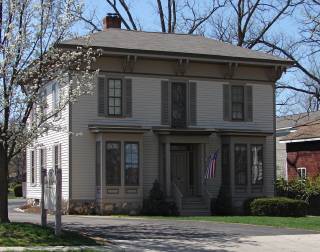
This Italian Revival house which once stood on Dixie Highway was moved to this site.
Since this property is in the heart of the old Village of Clarkston it seems likely that there were shops on this site early. However, at this time there are no specifics to relate until about 1872 when tax records listed J. M. Haight, a man of "tin, copper & iron ware" as the owner of a building whose footprint was shown of the 1872 Map of the Village.
This property was long associated with the Carran family. Joseph Carran owned the property by 1889. Elizabeth and her daughters, Victoria and Sarah, lived on the second floor at the turn of the century. (Sarah was a teacher.) After Victoria Carran married George Elliot they made their residence 61 South Holcomb St. The first floor was the millinery shop of the Mason sisters, Mary Mason, Mrs. Clarence Taylor, and Lucy Mason. See the 8/26/1968 Clarkston News photos & article by Constance Lektzian.
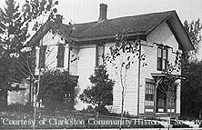 This first building was a late Victorian building. This house was demolished in 1958 after a fire damaged the Caribou Inn to the south.
In the 1920s John Walter had an "ice house" on the northeast corner of Lot 4 according to tax records. The building which stands on the lot now was moved, in 1984, from its original site on the north side of Dixie highway east of M-15, west of Maybee Rd. (the present site of a Burger King restaurant) was known as the "John Green" house. John Green came to Independence Township from New Jersey about 1849 to farm. The Green farm , in Section 29, may be seen on the 1872 Township Map. In the 1960s the house was a part of the Ritter Farm Market property.
 This Italian Revival style house was restored on the new site. The aluminum siding which had been applied over the wood clapboard was removed. The front porch was restored, a stone foundation was built by a local craftsman, and a new entrance was constructed on the rear in preparation for commercial/office & apartment use.
Official Property Description:
- Lot 4 Block 18 of Nelson W. Clark's Original Plat of the Village in the Southwest 1/4 of Section 20 in Independence Township.
- Lot 16 of the Supervisor's Replat of the Northwest Addition & Part of the Original Plat.
Significant Property History:
[A Synopsis Of Property Transfers Derived From Abstracts
(when available) And Periodic Changes In Ownership Or
Assessed Value Derived From Township Tax Records]
- Note: All the properties currently located in the Historic District were originally part of a tract registered by Butler Holcomb with the federal government on October 22, 1831. Thus, abstracts for these properties, when they exist, show the original transfer to be from the United States to Butler Holcomb and may also include references to then President Andrew Jackson.
-
- 1832 Butler Holcomb, the Northeast 1/4, the Southeast 1/4, the east 1/2 of the Northwest 1/4 and the east 1/2 of the Southwest 1/4 of Section 20.
- 1835 Butler Holcomb to Jeremiah Clark, the south part of the east 1/2 of the Southwest 1/4 of Section 20.
- 1839 Jeremiah Clark to Nelson W. Clark, one equal undivided half of the south part of the east 1/2 of the Southwest 1/4 of Section 20.
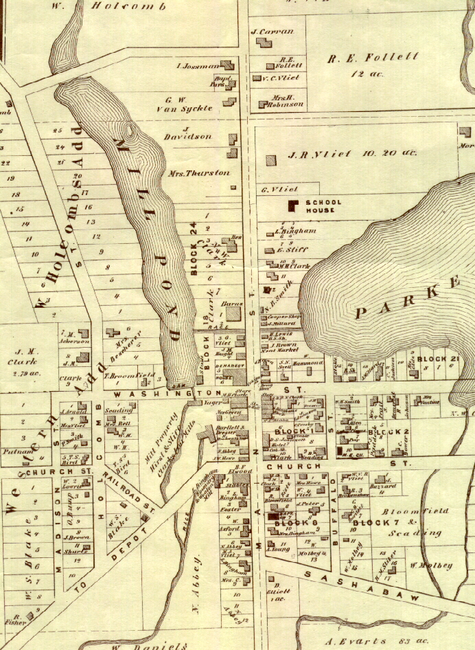
- 1842 Nelson W. Clark's Plat of the Village.
Originally on Nelson W.Clark's plat, this property did not extend to the east edge of the Mill Pond shore. A public way ran along the Mill Pond shore extending north from W. Washington to the stream/spillway from the Mill Pond to Park Lake. The public way was vacated in favor of riparian owners.
- 1832 U. S. to Butler Holcomb, the east 1/2 of the Southwest 1/4 of Section 20.
- 1843 Nelson W. & Phidelia Clark to Polly Clark, Blocks 13, 14, 15, & 16 and Lots 3, 4, 5 & 6 Block 18.
- 1844 Jeremiah Clark, Lot 3 Block 18, assessed value $5.
Jeremiah Clark, Lot 4 Block 18, assessed value $5.
Jeremiah Clark, Lots 5 & 6 Block 18, assessed value $260.
- 1846 Jeremiah Clark, Lots 3, 4, 5 & 6 Block 18, assessed value $200.
- 1847 Jeremiah Clark, Lots 3, 4, 5 & 6 Block 18, assessed value $200.
- 1848 Polly Clark, Lots 3, 4, 5 & 6 Block 18, assessed value $260.
- 1849 Polly A. Clark to H.G./Myron G. Cobb.
- 1850 H. G./Myron G. Cobb, Lots 3, 4, 5 & 6, assessed value $245.
- 1857 David Hoyt, Lots 3, 4, 5 & 6, assessed value $600.
- 1862 David Hoyt, Lots 3, 4 & 6, assessed value $450.
- 1867 Wm. V. Vliet, Lots 3 & 4, assessed value $350.
- 1872 Map of the Village has a building footprint, owner J.M. Haight. Lot 3.
- 1875 J. M. Haight, the "north" 1/2 of Lot 3, back on the southeast corner, assessed value $20 and Lot 4, assessed value $300.
- 1879 M. Demerest, Lot 4, assessed value $300. The "north 1/2" of Lot 3, assessed value $20.
- 1880 Matilda Demerest, the "west "1/2 of Lot 3, assessed value $50 and Lot 4, assessed value $500.
- 1883 Mrs. Mary Howe, Lot 4 & the north 1/2 of Lot 3, assessed value $500.
- 1889 J. P. Carran, the west 1/2 of Lots 3 & 4, assessed value $500.
- 1908 Map of the Village has a building footprint on Lot 4.
- 1925 E. Carran, Lot 4, assessed value $1300 and Lot 3, assessed value $400.
W. O. Clark, the southeast 1/4 of Lot 4 Block 18, assessed value $100.
John Walter,estate. Personal tax on Lot 4 Block 18.
- 1927 E.Carran, estate, Lot 4, assessed value $1200 & Lot 3 except the southeast 1/4, assessed value $400.
Jessie Walter the "northwest" corner of Lot 4, "Ice House" & W. Walter.
- 1930 Elizabeth Carran, Lot 4, assessed value $1200 & the lane to the Pond
Lot 3 except the southeast 1/4, assessed value $400.
Jean Looker, personal tax on Block 18.
Israel Ogden, personal tax on Block 18.
- 1950 Joseph P. Carran, estate. Lot 16.
- 1954 as above.
Site Conceived By
And Grant Funding Obtained By
Mollie Lynch, Library Director 1991-2005
Researched And Written By Susan K. Basinger
Web Pages Designed And Built By Bill And Susan
Basinger
Contents ©2000 Independence Township Library
All Rights Reserved