 Walking Tour-72 & 74 East Washington Street-Walking Tour
(South Side of Street)
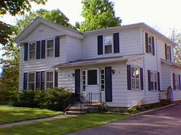
The original section of this house was built circa 1859, owner Sarah B. Vantine. Like the house across the Street it was built as a Midwestern adaptation of the Greek Revival style. Originally the house had a one & 1/2 (or two story) section on the east with a single story wing to the west. Subsequently, a second story was added to the wing. The broken pediment of the entablature typical of the style may still be seen on the street facing facade. Aluminum siding covers the original wood clapboard.
Official Property Description:
- The west part of Lots 2 & 3 Block 3 of Nelson W. Clark's Original Plat of the Village in the Southeast 1/4 of Section 20 in Independence Township.
- Lot 9 of the Assessor's Plat.
Significant Property History:
[A Synopsis Of Property Transfers Derived From Abstracts
(when available) And Periodic Changes In Ownership Or
Assessed Value Derived From Township Tax Records]
- Note: All the properties currently located in the Historic District were originally part of a tract registered by Butler Holcomb with the federal government on October 22, 1831. Thus, abstracts for these properties, when they exist, show the original transfer to be from the United States to Butler Holcomb and may also include references to then President Andrew Jackson.
- 1832 Butler Holcomb, the Northeast 1/4 , the Southeast 1/4, the east 1/2 of the Northwest 1/4 and the east 1/2 of the Southwest 1/4 of Section 20.
- 1835 Butler Holcomb to Jeremiah Clark, the south part of the west 1/2 of the Southeast 1/4 of Section 20.
- 1839 Jeremiah Clark to Nelson W.Clark, one equal undivided half of the west 1/2 of the Southeast 1/4 of Section 20.
- 1844 Nelson W. Clark, Block 3 of the Original Plat of the Village, assessed value $10.
- 1846 Nelson W. Clark, the east 1/2 of the Southeast 1/4 of Section 20, assessed value $140.
- 1847 Nelson W. Clark, the east 1/2 of the Southeast 1/4 of Section 20, assessed value $150.
- 1848 Nelson W. Clark, as above, assessed value $214.
- 1849 Nelson W. Clark, as above, assessed value $220.
- 1859 Sarah B. Vantine, assessed value $30.
- 1860 S. B. Vantine, assessed value $300.
- 1872 Map of the Village has a building footprint on this site, owner Mrs. Vantine.
- 1875 Sarah Vantine.
Mrs. Ransom Johnson, north by Park Lake, east by Sibley, south by D.Scadding and F.Smith, west by Mrs. Olds, Vantine and Bowers, assessed value $60.
- 1889 Sarah Vantine.
- 1904 John McMahon, north by Bird & Lewis & Washington Street, east , south & west by Mrs. Malvina Johnson, assessed value $300.
- 1914 Charles Vliet, assessed value $800.
- 1917 Charles Vliet, south & west by M.M. Johnson, assessed value $1000.
- 1919 Charles Vliet, north by W.C. Clark & Washington Street, east , south and west by Jennie Vliet, assessed value $1200.
- 1920 Jennie Vliet, north by the Street and Charles Bryant, east by the Creek, south by the Street and J. Petty, west by Gulick, assessed value $1800.
Charles Bryant ,north by owner unknown and Washington Street, east, south and west by Jennie Vliet, assessed value $2000.
- 1923 Jennie Vliet, north by Bryant and unknown, south by Green and Petty, west by J.Gulick, assessed value $1800.
Charles & Catherine Bryant, north by owner unknown, east by Vliet, west by Vliet, assessed value $4200.
- 1924 Jennie Vliet, north by the Street and Bryant, east by Bryant and the river, south by the river and Petty, west by Gulick, Petty, Green and Bryant, assessed value $2000.
Charles and Cynthia Bryant, north by the Street, east by Vliet, west by Vliet, Block 3.
- 1925 Jennie Vliet, south by the river and Parent, Petty estate and William Gulick, assessed value $2000.
Bryant, north by the Street, east by Vliet, west by river, Block 3, assessed value $4600.
- 1926 Vliet, south by Vliet, assessed value $4600.
Bryant, north by the Street, east by Vliet & the river, west by Vliet, south by Vliet, assessed value $4600.
- 1929 Jennie Vliet, as above, assessed value $1900.
Bryant , part of Blocks 3 & 4 , north by Washington, east by the river, west by Vliet, south by Vliet, assessed value $5000.
- 1935 Jennie Vliet, the west 1/2 of Lots 2 & 3 and Lots 5 to 10 including Block 3 except beginning at the southwest corner of Lot 10, then 198 feet, then east 21.5 ft., then south 35 ft., then east 90.75 ft., then south 163 ft., then west 112.25 ft. to beg.
Bryant, Lots 1 & 4 and the east 1/2 of Lots 2 & 3 Block 3, assessed value $3750.
- 1941 Ward Dunston and Ray Jarvis, Lot 9.
- 1948 Fern T. Crosby, Lot 9.
- 1954 Fern T. Crosby, Lot 9.
- 1956 Shanks.
Site Conceived By
And Grant Funding Obtained By
Mollie Lynch, Library Director 1991-2005
Researched And Written By Susan K. Basinger
Web Pages Designed And Built By Bill And Susan
Basinger
Contents ©2000 Independence Township Library
All Rights Reserved

![]() Walking Tour-72 & 74 East Washington Street-Walking Tour
Walking Tour-72 & 74 East Washington Street-Walking Tour![]()

![]() Walking Tour-72 & 74 East Washington Street-Walking Tour
Walking Tour-72 & 74 East Washington Street-Walking Tour![]()