 Walking Tour-165 North Main Street-Walking Tour
(West Side of Street)
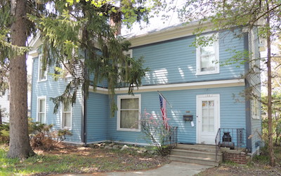
The original sections of this house were built in the Greek Revival style probably for William Holcomb who also owned the Lots of the two houses to the south and the one to the north.
This house was built before 1872 as a Midwestern adaptation of the Greek Revival style, a reverse plan of the two houses to the south. The two story section with a broken pediment gable facing the street on the south and the original single story section to the north. While the house may have been built by William Holcomb or William Van Buskirk Vliet it was also for a time the home of prominent Clarkston businessman Isador/Esidor Jossman, merchant and founder of Clarkston's first bank. The second story of the north wing is an addition.
Official Property Description:
- The southeast corner of the Northwest 1/4 of Section 20 in Independence Township which was not a part of Nelson W. Clark's Original Plat.
- Lot 45 of Supervisors Plat No. 1.
Significant Property History:
[A Synopsis Of Property Transfers Derived From Abstracts
(when available) And Periodic Changes In Ownership Or
Assessed Value Derived From Township Tax Records]
- Note: All the properties currently located in the Historic District were originally part of a tract registered by Butler Holcomb with the federal government on October 22, 1831. Thus, abstracts for these properties, when they exist, show the original transfer to be from the United States to Butler Holcomb and may also include references to then President Andrew Jackson.
- 1832 Butler Holcomb, the Northeast 1/4, the Southeast 1/4, the east 1/2 of the Northwest 1/4 and the east 1/2 of the Southwest 1/4 of Section 20.
- 1846 William Holcomb, the south 3/4 of the Northwest 1/4 of Section, assessed value $395.
- 1847 William Holcomb, the south 3/4 of the Northwest 1/4, assessed value $350.
- 1848 William Holcomb, the south part of the Northwest 1/4, assessed value $382.
- 1849 William Holcomb, the south 3/4 of the Northwest 1/4, assessed value $412
- 1850 William Holcomb, the south 3/4 of the Northwest 1/4 of Section 20, assessed value $420.
- 1868 William B. (V. B.) Vliet , a piece of land bound on the north & east by the Highway, west by the Pond, south by J.D, assessed value $350.
- 1870 William V. B. Vliet, north & east by the Highway, south by J. D. & the Baptist parsonage, assessed value $500.
- 1871 E. Jossman, north & east by the Highway, south by the Baptist parsonage & G. VanSyckle, west by the Pond, assessed value $550.
- 1872 Map of the Village has a building footprint, owner I. (Isador/ Esidor) Jossman.
- 1904 E. Jossman, estate, assessed value $1200.
- 1918 E. Jossman, estate, assessed value $2500. His property now included the property behind 155 N. Main to the Mill Pond.
- 1920 William Ford, north & east by the Street, south by the 1/4 Section line, west by the Pond except Ogden, Clark, & Alger.
- 1923 as above.
- 1929 Harold Vaughn
- 1935 Paul Kanold, Lot 45.
- 1941 John C. Breakey.
- 1954 James A. Glennie.
Site Conceived By
And Grant Funding Obtained By
Mollie Lynch, Library Director 1991-2005
Researched And Written By Susan K. Basinger
Web Pages Designed And Built By Bill And Susan
Basinger
Contents ©2000 Independence Township Library
All Rights Reserved

![]() Walking Tour-165 North Main Street-Walking Tour
Walking Tour-165 North Main Street-Walking Tour![]()

![]() Walking Tour-165 North Main Street-Walking Tour
Walking Tour-165 North Main Street-Walking Tour![]()