 Walking Tour-61 East Washington Street-Walking Tour
(North Side of Street)
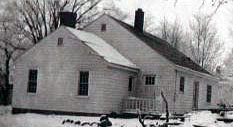
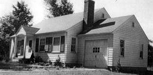
 The original section of this Cape Cod style house was built by Otto Hildebrand in the 1940s. The rear of the house as it was under construction may be seen to the left while the front of the house may be seen in the photo below to the right. Hildebrand was manager/caretaker of Colonel Sidney Dunn Waldon's Pine Knob Estate. This house was meant to be Hildebrand's retirement home according to his daughter, but the family never lived here. The Hildebrands left the area after Waldon's death in 1945.
Historically tax records indicate a building on this lot by 1915, owner Henriette Loomis. Reportedly this house burned in the 1930s. There are no photographs or reports of the appearance of the first house available.

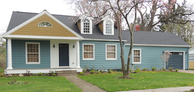
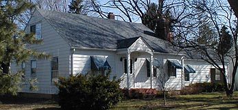
The house was remodeled in 2013 with the addition of the dormers and a new front porch. A picture of the house prior to the remodeling is shown to the left.
Official Property Description:
- The east 46.5' of Lot 1 Block 20 & Franklin St. (85') of Nelson W. Clark's Original Plat of the Village in the Southeast 1/4 of Section 20 of Independence Township.
- Lot 5 of the Assessor's Plat.
Significant Property History:
[A Synopsis Of Property Transfers Derived From Abstracts
(when available) And Periodic Changes In Ownership Or
Assessed Value Derived From Township Tax Records]
- Note: All the properties currently located in the Historic District were originally part of a tract registered by Butler Holcomb with the federal government on October 22, 1831. Thus, abstracts for these properties, when they exist, show the original transfer to be from the United States to Butler Holcomb and may also include references to then President Andrew Jackson.
- 1832 Butler Holcomb, the Northeast 1/4, the Southeast 1/4, the east 1/2 of the Northwest 1/4 and the east 1/2 of the Southwest 1/4 of Section 20.
- 1835 Butler Holcomb to Jeremiah Clark, the south part of the west 1/2 of the Southeast 1/4 of Section 20.
- 1839 Jeremiah Clark to Nelson W. Clark, one equal undivided half of the west 1/2 of the Southeast 1/4 of Section 20.
- 1849 Nelson W. Clark, the east 1/2 of the Southeast 1/4 of Section 20, assessed value $220.
- 1871 Map of the Village has no building footprint, owner C.A. Jackson.
- 1902 C. A. Jackson, assessed value $50.
- 1902 C. A. Jackson, assessed value $300.
- 1915 C. A. Jackson, assessed value $700.
- 1919 C. A. Jackson, estate, Land bound by Park lake, east by Curl, south by Street, west by White, assessed value $700.
- 1920 C. A. Jackson, estate, assessed value $1000.
- 1923 Henriette Loomis, assessed value $800.
- 1924 Henriette Loomis, assessed value $900.
- 1935 Henriette Loomis, beginning at the southwest corner of Lot 9 Block 21, west 96'.
- 1936 Henriette Loomis, Lot 1 Block 20 and the east 6' of Lot 2 and all of Franklin Street.
- 1937 Henriette Loomis, the east 46.5 of Lot 1 Block 1 & Franklin Street.
- 1940 Otto Hildebrand, the east 45.5' of Lot 1 & Franklin Street.
- 1941 Otto Hildebrand, Lot 5.
- 1948 Otto Hildebrand, Grosse Point, Mich.
- 1950 Byron Nolan.
Site Conceived By
And Grant Funding Obtained By
Mollie Lynch, Library Director 1991-2005
Researched And Written By Susan K. Basinger
Web Pages Designed And Built By Bill And Susan
Basinger
Contents ©2000 Independence Township Library
All Rights Reserved

![]() Walking Tour-61 East Washington Street-Walking Tour
Walking Tour-61 East Washington Street-Walking Tour![]()

![]() Walking Tour-61 East Washington Street-Walking Tour
Walking Tour-61 East Washington Street-Walking Tour![]()
 The original section of this Cape Cod style house was built by Otto Hildebrand in the 1940s. The rear of the house as it was under construction may be seen to the left while the front of the house may be seen in the photo below to the right. Hildebrand was manager/caretaker of Colonel Sidney Dunn Waldon's Pine Knob Estate. This house was meant to be Hildebrand's retirement home according to his daughter, but the family never lived here. The Hildebrands left the area after Waldon's death in 1945.
