 Walking Tour-31 South Main Street-Walking Tour
(West Side of Street)
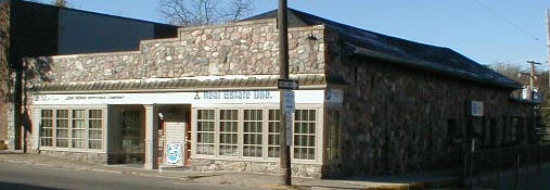
Historically there was more than one building on this lot which served various purposes; warehouse, foundry, carding mill, and stable. The building seen on the east part of the lot is the only one left. While it also served various purposes, in recent years it has been used for retail commercial and office space. The building's appearance has changed many times since originally constructed. In June 1999 the pent roof was removed and the large plate glass windows were replaced with divided pane windows.
Commercial buildings have occupied this corner of South Main Street and Depot Road (once called Livery Hill) at least since 1844. Tax records of that year listed Isaac Place for the property with the assessed value of $300, high enough to indicate major acitivity on the lot then. The listing in 1848 became Place and Hirst. ( A first name for Hirst is not noted. One of the Hirsts, Ed. S. Hirst, became the partner of Nelson W. Clark in the mill property north of Depot Road, owning it outright by 1859.) Stark and Hirst owned the west part of this Lot in 1850. The building on the site then was probably a mill operation. Beginning 1855 Taylor H. Stewart was listed, with his son, for a "clothing works" and a "dwelling house" on this property. John G. Owen had a building on the corner listed in tax records by 1859 as the site of a warehouse and storehouse. By 1860 Enos Church owned a furnace, carding mill/cloth dressing operation (previousl located on East Washington Street ) and a dwelling house on the site.
The 1872 map of the Village has the footprints of two buildings on this lot. B. F. Elwood had a large building fronting on Main and was listed for a livery stable, while Lee Bingham had a building at the back of the lot with another joining it to the west designated as a foundry and wooden mill. Bingham was also listed for a building on Lot 2. This back building was probably his residence for a time.
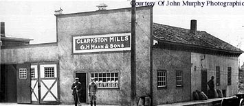
 These early wooden buildings (with stone foundations) may be seen in photos circa 1910 ( photo left ); circa 1924 of the Clarkston Mills (not shown ); & circa 1940 (not shown) of G. H. Mann and Sons .
In the 1930s there was a feed store at this location which was remodeled in 1940 when the cut field stone was added to the facade. Casper Warden, a local mason,
( residence, 26 Buffalo St ) is credited with the work. Rudy's Market, Rudolph Schwarze, proprietor, moved here following a fire in 1939 which destroyed the wooden buildings on the southwest corner of S. Main & W. Washington where he was previously located. Schwarz moved to the building at 9 S. Main Street in 1954.
In 1954 there was an ad in the Clarkston News for Mr. and Mrs. J. R. Cashion's business, The Dairy Bar, in this building. The Clarkston Town Shop, a clothing store, was located here in the late 1960s. The 1970s saw the building converted to the Clarkston Emporium with a number of small boutiques occupying the basement as well as the main floor. Reclaimed architectural elements were used to remodel the interior and exterior (i.e. the stained glass door on the Main Street facade). In recent years the main floor has been used for offices.
Official Property Description:
- Lot 1 Block 26 of Nelson W. Clark's Original Plat of the Village in the Southwest 14 of Section 20 of Independence Township.
- Lot 73 of the Assessor's Plat.
Significant Property History:
[A Synopsis Of Property Transfers Derived From Abstracts
(when available) And Periodic Changes In Ownership Or
Assessed Value Derived From Township Tax Records]
- Note: All the properties currently located in the Historic District were originally part of a tract registered by Butler Holcomb with the federal government on October 22, 1831. Thus, abstracts for these properties, when they exist, show the original transfer to be from the United States to Butler Holcomb and may also include references to then President Andrew Jackson.
- 1844 Isaac Place, Lot 1 Block 26, assessed value $300.
- 1846 Isaac Place, Lot 1 Block 26, assessed value $140.
- 1847 Isaac Place, Lot 1 Block 26, assessed value $140.
- 1848 Place & Hirst, Lot 1 Block 26, assessed value $320.
- 1849 Place & Hirst, Lot 1 Block 26, assessed value $345.
- 1850 Eleazer James, the east 12 of Lots 1 & 2 Block 26, assessed value $190.
- 1855 Stark & Hurst/Hirst, west 1/2 of lots 1 & 2 Block 26, assessed value $320.
- 1857 John G. Owen, 48'x 82 &1/2' on the northeast corner of Lot 1,
assessed value $350.
Geo. W. Smith, the rest of the east 1/2 of Lot 1, assessed value $70.
T. H. (Taylor) Stewart, the west 1/2 of Lot 1, assessed value $300.
- 1857 J. G. Owen, as above.
Taylor Stewart, an 18'x 24' building in the southeast corner of
the east 1/2 of Lot 1.
- 1859 John Owen, part of Lot 1, assessed value $350, "warehouse".
Taylor H. Stewart/Stuart and Son, Lot 1, "clothing works and dwelling house".
- 1860 J. G. Owen, "storehouse".
Enos Church, 18'x24' on the west 1/2 Lots 1 & 2 Block 26, assessed value $800. furnace (which he moved from E. Washington Street location to this site) "carding mill/cloth dressing and dwelling house".
- 1870 Lee Bingham, 18'x24', as above.
- 1872 Map of the Village B. F. Elwood, building footprint, livery stable.
Tax records: Lee Bingham, the east part of Lot 1 Block 26.
The Lee Bingham building footprint on the map was a foundry and woolen mill.
Clarence Paddock, 18'x24' off the south side of the east 1/2 of Lot 1 Block 26, assessed value $50. Also the east 1/2 of lot 2 Block 26, assessed value $400.
- 1889 Peter Green, 48'on Main x 82'1/2' on the northeast corner of Lot 1 Block 26.
John West, west 1/2 of Lot 1, assessed value $200.
- 1891 Peter Green, as above.
- 1896 Jasper Linabury, part of Lot 1 Block 26.
Peter Green, 48'x 82'1/2'.
- 1900 Peter Green, as above, assessed value $500.
- 1904 Peter Green, assessed value $400.
- 1910 Dr. Clark Sutherland, 48'x 82 & 1/2 'on the northeast corner, assessed value $400.
W. E. Clark and Esidor Jossman, east 1/2 of Lot 1.
Mrs. S. L. (Sarah) Linabury, Lot 2 & the south 15' of Lot 1.
- 1917 Mrs. S. L. Linabury, Lot 2 & the south 15' of Lot 1, assessed value $1300, & Lot 3, assessed value $700.
- 1918 Fred Stewart, 48'x 82 &1/2' of Lot 1, assessed value $500.
- 1924 Geo.Mann, 48' x 82 & 1/2'.
- 1929 Armold Mann, Lot 1 Block 26.
- 1935 George Smith, a stone mason, purchased the building, & ran a feed store here, then the "Dairy Bar", with his wife Adeline.
Site Conceived By
And Grant Funding Obtained By
Mollie Lynch, Library Director 1991-2005
Researched And Written By Susan K. Basinger
Web Pages Designed And Built By Bill And Susan
Basinger
Contents ©2000 Independence Township Library
All Rights Reserved

![]() Walking Tour-31 South Main Street-Walking Tour
Walking Tour-31 South Main Street-Walking Tour![]()

![]() Walking Tour-31 South Main Street-Walking Tour
Walking Tour-31 South Main Street-Walking Tour![]()
 These early wooden buildings (with stone foundations) may be seen in photos circa 1910 ( photo left ); circa 1924 of the Clarkston Mills (not shown ); & circa 1940 (not shown) of G. H. Mann and Sons .