 Walking Tour-164 North Main Street-Walking Tour
(East Side of Street)
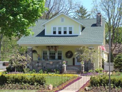
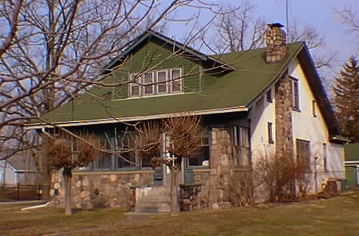
This house was built for Dr. Raymond Miller shortly after he bought the property in 1924. Dr. Miller was the son of C. C. Miller, one of 5 physicians who founded old Grace Hospital, Detroit. Raymond Miller used this native stone bungalow as his office and residence. Clarkston resident, Casper Warden did the stone & plaster work for this house. Previously, the porch was glassed-in and served as the patient waiting room (see photo below). The porch glass was removed and some of the windows replaced during an extensive renovation in 2009-2010.

While this house dates from 1924 there was a structure here by 1872. The 1872 Map of the Village has the footprint of a square building on the property, owner R. E. Follett. There is no information now to indicate the use or appearance of the building. Reportedly the home burned.
Official Property Description:
- Part of the west 1/2 of the Northeast 1/4 of Section 20 of Independence Township, not a part of Nelson W. Clark's Original Plat of the Village.
- Lot 48 of the Supervisor's Replat No.1.
Significant Property History:
[A Synopsis Of Property Transfers Derived From Abstracts
(when available) And Periodic Changes In Ownership Or
Assessed Value Derived From Township Tax Records]
- Note: All the properties currently located in the Historic District were originally part of a tract registered by Butler Holcomb with the federal government on October 22, 1831. Thus, abstracts for these properties, when they exist, show the original transfer to be from the United States to Butler Holcomb and may also include references to then President Andrew Jackson.
- 1844 Ebenezer Clark, the west 1/2 of the Northeast 1/4 of Section 20, assessed value $200.
Jacob Walter, 1 acre in the corner of the southwest 1/4 of the Northeast 1/4 of Section 20, assessed value 420.
- 1847 Joseph Chapman the west 1/2 of the Northeast 1/4 of Section 20, assessed value $150.
- 1848 Joseph Chapman, the west 1/2 of the Northeast 1/4, assessed value $169.
- 1850 Joel Griffith, the west 1/2 of the Northeast 1/4 of Section 20
- 1856 Joseph Harris.
- 1858 Mary Ann/Marian Harris, the west 1/2 of the Northeast 1/4 except that which was sold to H. Robinson.
- 1860 P. E. Edmonson. "House", assessed value $350.
- 1861 Pheobe Edmonson, assessed value $350.
- 1864 William Hammond.
- 1867 Smith.
- 1870 R. E. Follett.
- 1872 Map of the Village has a building footprint on this site, assessed value $525.
- 1889 A. J. Crosby.
- 1896 Map of the Village, owner, A. J. Crosby.
- 1904 A. J. Crosby, estate, assesed value $1200.
- 1905 as above.
- 1906 Robert Kirchner/Kirchener, assessed value $1000.
- 1919 Robert & Nettie Kirchner, assessed $1600.
- 1920 Charles Hoyt, assessed value $2000.
- 1923 Thomas Cruice, assessed value $2000.
- 1924 Raymond Miller, assessed value $2500.
- 1940 as above.
Site Conceived By
And Grant Funding Obtained By
Mollie Lynch, Library Director 1991-2005
Researched And Written By Susan K. Basinger
Web Pages Designed And Built By Bill And Susan
Basinger
Contents ©2000 Independence Township Library
All Rights Reserved

![]() Walking Tour-164 North Main Street-Walking Tour
Walking Tour-164 North Main Street-Walking Tour![]()

![]() Walking Tour-164 North Main Street-Walking Tour
Walking Tour-164 North Main Street-Walking Tour![]()
