 Walking Tour-148 North Main Street-Walking Tour
(East Side of Street)
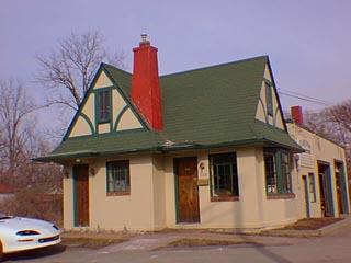
The original section of this Tudor Revival style service station was built in 1930 on the site of a nineteen century building.
Oral history has it that in 1840 one of Clarkston's earliest schools stood on this site. Clara Anderson was the teacher. By 1856 the property belonged to Dr. Horace Robinson. This was probably the site of his home. Dr. Robinson and Dr. Nelson Abbey were the first to engage in the drug business in the Village in a building on the northeast corner of N. Main & E. Washington Streets. Dr. Robinson died in a hunting accident in 1873.
The 1872 Map of the Village has a building footprint on this site the configuration of which conforms to many of the simple early Midwestern adaptations of the Greek Revival style houses built in the area. That is, an L-shaped footprint. No pictures of this house are available.
The property remained in the Robinson family until 1930 when it was sold to Frank Leonard and brothers, Ed. A. and Joseph J. Seeterlin. (These three men had car dealerships on the southeast corner of S. Main St. and E. Church St.) Here they entered into a lease with Standard Oil Co. and the present Tudor Revival style building & driveways were constructed at a cost of $6,000.00. According to the Historic Building/Structure Inventory Form - "When this property was first operated as a gasoline station it was very well landscaped with a water fountain, and looked very much like a home".
Official Property Description:
- The southwest corner of the Northeast 1/4 of Section 20 in Independence Township, not a part of Nelson W. Clark's Original Plat of the Village.
- Lot 50 of Supervisor's Plat No.1.
Significant Property History:
[A Synopsis Of Property Transfers Derived From Abstracts
(when available) And Periodic Changes In Ownership Or
Assessed Value Derived From Township Tax Records]
- Note: All the properties currently located in the Historic District were originally part of a tract registered by Butler Holcomb with the federal government on October 22, 1831. Thus, abstracts for these properties, when they exist, show the original transfer to be from the United States to Butler Holcomb and may also include references to then President Andrew Jackson.
- 1840 the site of a schoolhouse. Teacher Clara C. Anderson.
- 1844 Ebenezer Clark, the west 1/2 of the Northeast 1/4 of Section 20, assessed value $200.
Jacob Walter, 1 acre in the corner of the southwest 1/4 of the Northeast 1/4 of Section 20, assessed value 420.
- 1847 Joseph Chapman, the west 1/2 of the Northeast 1/4 of Section 20, assessed value $150.
- 1848 Joseph Chapman, the west 1/2 of the Northeast 1/4, assessed value $169.
- 1850 Joel T. Griffith, the west 1/2 of the northeast 1/4 of Section, assessed value $250.
- 1855 Horace Robinson, 1 acre on the southwest corner of the southwest 1/4 of the northeast 1/4.
- 1856 Horace Robinson, as above.
- 1872 Map of the Village shows a building footprint on this site, owner H. Robinson.
- 1873 Horace Robinson died.
- 1889 L. C. Robinson.
- 1896 Map of the Village, owner Mrs. L. E. Robinson.
- 1911 Mrs. L. E. (Cynthia) Robinson, assessed value $1000.
- 1923 as above.
- 1930 Cynthia Robinson sold to Ed. A. Seeterlin, Joseph J. Seeterlin & Frank Leonard.
- 1940 as above.
- 1954 Harry J. & Grace Fuller.
Site Conceived By
And Grant Funding Obtained By
Mollie Lynch, Library Director 1991-2005
Researched And Written By Susan K. Basinger
Web Pages Designed And Built By Bill And Susan
Basinger
Contents ©2000 Independence Township Library
All Rights Reserved

![]() Walking Tour-148 North Main Street-Walking Tour
Walking Tour-148 North Main Street-Walking Tour![]()

![]() Walking Tour-148 North Main Street-Walking Tour
Walking Tour-148 North Main Street-Walking Tour![]()