 Walking Tour-14 North Main Street-Walking Tour
(East Side of Street)
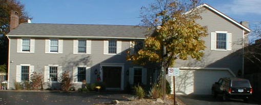
The pseudo Federal style apartment building which now stands on this site was constructed in 1972. A second story was added to the garage in June of 1999.
This site was a part of the property of Jeremiah Brown in 1847. 1859 tax records cited a house & barn here belonging to Brown. Brown had a meat market north of this house. The 1872 map of the Village shows the footprint of the building. A photo, page 52, Heritage shows a Greek Revival style building with the addition of a porch across the entire Main Street facade. Emma Brown, Jeremiah's widow (a dressmaker), then Lottie/Lettie Bradley, the Brown's daughter, continued to own the property until 1935.
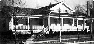
 According to an 8/30/1935 Clarkston News article, Dr. Arthur W. Shurz purchased the Bradley property just north of the Clarkston Bakery. He "will move the building north" & open a dental office. Dr. Stackable, also a dentist, occupied the building (see photo right) as his office & residence until it was destroyed in a fire in 1961.
Note the tax records show that the Brown's property included the Park Lake shore line to the east as far as Buffalo St. which originally extended all the way north to the lake.
Official Property Description:
- the north 1/2 Lots 6 & 5 Block 19 of Nelson W. Clark's Original Plat of the Village in the Southeast 1/4 of Section 20 in Independence Township.
- Lot 36-37 ( the south 116.71' of Lot 36) of the Supervisor's Replat of the Northwest Addition and part of the Original Plat.
Significant Property History:
[A Synopsis Of Property Transfers Derived From Abstracts
(when available) And Periodic Changes In Ownership Or
Assessed Value Derived From Township Tax Records]
- Note: All the properties currently located in the Historic District were originally part of a tract registered by Butler Holcomb with the federal government on October 22, 1831. Thus, abstracts for these properties, when they exist, show the original transfer to be from the United States to Butler Holcomb and may also include references to then President Andrew Jackson.
- 1846 Arthur Davis, Lots 6 & 9 Block 19, assessed value $150.
- 1847 Jeremiah Brown, the west 1/2 of Lots 6 & 9 Block 19, assessed value $100.
- 1848 Jeremiah Brown, the west 1/2 of Lots 6 & 9 Block 19, assessed value $195.
- 1850 Jeremiah Brown the west 1/2 of Lots 6 & 9.
A. Benjamin the east 1/2 of Lots 6 & 9.
- 1859 Jeremiah Brown the west 1/2 of Lots 5, 6 & 9 Block except 62' x 27 1/2 which was sold to Abbey & Robinson & except 42' front on Main x 72' back, a part on Lot 9 & part on Lot 6 "House & Stable".
- 1870 Jeremiah Brown, Lots 3, 5, 6 & 9, assessed value $570.
- 1872 Map of the Village has no footprint of a building of this site.
- 1889 Emma Brown.
- 1900 Emma Brown, Lots 3, 5 & 6, assessed value $600.
- 1914 Emma Brown, the west 1/2 of Lots 5 & 6 & the south 1/4 of the west 1/2 of Lot 3, assessed value $1050.
- 1918 Lottie/Lettie Bradley, north by Andrews, Denby, & Park Lake, east by Buffalo St. & Fleming, south by Smith, Fleming & Leonard, west by Main & Andrews, assessed value $1200.
- 1919 Lottie/Lottie Bradley, east by Buffalo & Weiland, south by Smith, Wailand & Shaughnessy, west by Main & Andrews, assessed value $1200.
- 1920 as above.
- 1925 L. Bradley, the north 1/2 of Lots 5 & 6 except 56' x 100' in the northwest corner to Floyd Andrews.
- 1927 L. Bradley, the north 1/2 of Lots 5 & 6 except 56' x 100' in the northwest corner to Guy Brown, assessed value $1500.
- 1930 L. Bradley, the north 1/2 of Lots 5 & 6, assessed value $1800.
- 1933 L. Bradley.
- 1940 A. W. & Harriet Schurz, Lot 36.
- 1941 as above, Lots 35 & 36.
- 1950 D. T. Stackable, the south 116' of Lot 36.
- 1961 the house burned.
Site Conceived By
And Grant Funding Obtained By
Mollie Lynch, Library Director 1991-2005
Researched And Written By Susan K. Basinger
Web Pages Designed And Built By Bill And Susan
Basinger
Contents ©2000 Independence Township Library
All Rights Reserved

![]() Walking Tour-14 North Main Street-Walking Tour
Walking Tour-14 North Main Street-Walking Tour![]()

![]() Walking Tour-14 North Main Street-Walking Tour
Walking Tour-14 North Main Street-Walking Tour![]()
 According to an 8/30/1935 Clarkston News article, Dr. Arthur W. Shurz purchased the Bradley property just north of the Clarkston Bakery. He "will move the building north" & open a dental office. Dr. Stackable, also a dentist, occupied the building (see photo right) as his office & residence until it was destroyed in a fire in 1961.