 Walking Tour-53 E. Church Street-Walking Tour
(North Side of Street)
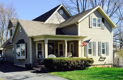
This house was reportedly constructed, circa 1880, as a carriage house for the home to the west, 47 E. Church Street. The house has changed a great deal over the years. A single story addition constructed to the rear, was done in the 1980s. The roundel window with the dentil molding of the window hood in the west gable is an old detail. A second story was constructed on the addition in 2012 adding a west facing dormer and an additional front facing gable.
Official Property Description:
- Part of vacated Franklin Street and part of Lots 10, 7, 6 , Block 3 of Nelson W. Clark's Original Plat of the Village in the Southeast 1/4 of Section in Independence Township. Lot 20 of the Assessor's Plat.
Significant Property History:
[A Synopsis Of Property Transfers Derived From Abstracts
(when available) And Periodic Changes In Ownership Or
Assessed Value Derived From Township Tax Records]
- 1831 United States to Butler Holcomb.
- 1833 Butler Holcomb & wife, Mary To Roswell/Roosevelt Holcomb, the west 1/2 of the Southeast 1/4 of Section 20.
- 1833 Butler Holcomb & wife, Mary To Roswell/Roosevelt Holcomb, and wife, Elvine Holcomb, and Daniel B. Holcomb and wife, Alimira to Jeremiah Clark, the south part of the west 1/2 of the Southeast 1/4 of Section 20.
- 1839 Jeremiah Clark to Nelson Washington Clark, the undivided 1/2 of the west 1/2 of the Southeast 1/4 of Section 20 commencing.......
- 1842 Jeremiah Clark & wife, Polly to Nelson W. Clark, the south part of the west 1/2 of the Southeast 1/4 of Section 20. Also other land.
- 1842 Jeremiah Clark & Nelson W. Clark to Village of Clarkston (Original plat of the Village).
- 1844 Nelson W. Clark, Block 3 of the Original Plat of the Village, assessed value $10.
- 1846 Nelson W. Clark, the east 1/2 of the Southeast 1/4 of Section 20, assessed value $140.
- 1847 Nelson W. Clark, the east 1/2 of the Southeast 1/4 of Section 20, assessed value $150.
- 1848 Nelson W. Clark, as above, assessed value $214.
- 1872 part of Nelson W. Clark's property.
1889 Jacob Petty, north by R. Johnson, east by R. Johnson and Frank Smith, west by C. Bower estate, south by the street, assessed value $400.
1904 Jacob Petty, north by R. Johnson, east by R. Johnson and Frank Smith, west by C. Bower estate, south by the street, assessed value $400.
1918 Jacob Petty, north by R. Johnson, east by R. Johnson and Frank Smith, west by C. Boser estate, south by the street, assessed value $400.
1948 Mrs. Margaret (Guy) Hart.
circa 1965 Hazen Atkins.
Site Conceived By
And Grant Funding Obtained By
Mollie Lynch, Library Director 1991-2005
Researched And Written By Susan K. Basinger
Web Pages Designed And Built By Bill And Susan
Basinger
Contents ©2000 Independence Township Library
All Rights Reserved

![]() Walking Tour-53 E. Church Street-Walking Tour
Walking Tour-53 E. Church Street-Walking Tour![]()

![]() Walking Tour-53 E. Church Street-Walking Tour
Walking Tour-53 E. Church Street-Walking Tour![]()