 Walking Tour-67 Buffalo Street-Walking Tour
(East Side of Street)
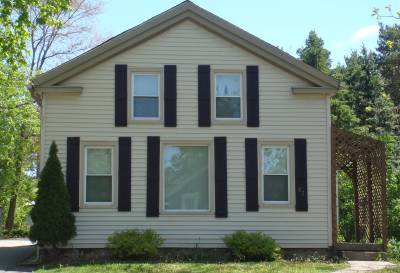
The original section of this Greek Revival house was built by 1860 for William Molbey/Malby, one of Clarkston's early settlers.
The information collected in 1976 for the Historic Building/Structure Inventory Form, listed this home as being on Lot 10 Block 1, (meaning Block 7), but that is the site of 61 Buffalo. This house is on Lot 11 of Block 7 as it corresponds with the 1872 map footprint. Now 66' of Lot 31.
There was probably a house or building on this lot by 1860, owner, William Molbey/Malby. Now covered with artificial siding simulating original wood clapboard, the original structure was Greek Revival with the broken pediment gable end facing the street.
Official Property Description:
- Lot 11 Block 7 of Nelson W. Clark's Original Plat of the Village in the Southeast 1/4 of Section 20 in Independence Township.
- 66' of Lot 31 of the Assessor's Plat.
Significant Property History:
[A Synopsis Of Property Transfers Derived From Abstracts
(when available) And Periodic Changes In Ownership Or
Assessed Value Derived From Township Tax Records]
- 1831 United States to Butler Holcomb.
- 1833 Butler Holcomb & wife, Mary To Roswell/Roosevelt Holcomb, the west 1/2 of the Southeast 1/4 of Section 20.
- 1833 Butler Holcomb & wife, Mary To Roswell/Roosevelt Holcomb, and wife, Elvine Holcomb, and Daniel B. Holcomb and wife, Alimira to Jeremiah Clark, the south part of the west 1/2 of the Southeast 1/4 of Section 20.
- 1839 Jeremiah Clark to Nelson Washington Clark, the undivided 1/2 of the west 1/2 of the Southeast 1/4 of Section 20 commencing.......
- 1842 Jeremiah Clark & wife, Polly to Nelson W. Clark, the south part of the west 1/2 of the Southeast 1/4 of Section 20. Also other land.
- 1842 Jeremiah Clark & Nelson W. Clark to Village of Clarkston (Original plat of the Village).
- 1844 Nelson W. Clark, Lot 11 Block 7, assessed value $6.
- 1847 Jeremiah Clark, the west 1/2 of Block 7 except Lot 2, assessed value $10.
- 1850 Nelson Washington Clark
- 1855 William Malby, Lots 11, 14, & 15 Block 7, assessed value $75.
- 1860 William Molbey, Lots 11, 4, & 15 Block 7, assessed value $250.
- 1863 William Molbey, Lots 11, 14, & 15, assessed value $400.
- 1872 Map William Molbey has a building footprint. William Molbey/Malby, Lots 11, 14 & 15.
- 1904 Miss Francis Jones, Lots 11, 14, & 15 Block 7, assessed value $300.
- The Pontiac Daily Press, 10/20/1904, "Francis Follett has completed exterior repairs on the house he purchased in the southern part of the village and moves his family into it this week."
- 1910 Francis Follett.
- 1920 Francis Follett, Lots 11, 14, & 15, assessed value $1200.
- 1925 Francis Follett, Lots 14 & 15.
Finette Bower, Lot 11 Block 7, assessed value $200.
- 1926 Finette Bower, Lot 11 Block 7, assessed value $200.
- 1933 Francis Follette Estate, Lots 11, 14, & 15, assessed value $800.
- 1943 Gertrude Green, Lot 3, assessed value $600.
- 1944 Gertrude Green, the north 66' of Lot 31, assessed value $700.
- 1952 Gertrude Green, as above, assessed value $1200.
Site Conceived By
And Grant Funding Obtained By
Mollie Lynch, Library Director 1991-2005
Researched And Written By Susan K. Basinger
Web Pages Designed And Built By Bill And Susan
Basinger
Contents ©2000 Independence Township Library
All Rights Reserved

![]() Walking Tour-67 Buffalo Street-Walking Tour
Walking Tour-67 Buffalo Street-Walking Tour![]()

![]() Walking Tour-67 Buffalo Street-Walking Tour
Walking Tour-67 Buffalo Street-Walking Tour![]()